
What type of volcano is Pacaya?
Read Pacaya classification by source and scale. Understand composite landform, volcanic complex and individual cones without inferring current activity.
Last reviewed October 2026
Contents20
- Pacaya volcano type in the primary record
- Why a complex can contain a stratovolcano
- Composite volcano and stratovolcano in plain language
- A cone, a crater and a vent are distinct things
- Domes and flows in the wider account
- Rock type is another question
- Type is not the same as eruption style
- Active, dormant and extinct do not replace the form label
- Formation history helps explain the variety
- Reading the source at the right scale
- A worked reading of two short descriptions
- Why a photo is not a type label test
- A small glossary for reading Pacaya descriptions
- Avoiding the most common label mistakes
- The regional setting does not make the volcanoes identical
- What the type label tells a visitor
- How to write a concise sourced answer
- Read the named features without merging them
- Limits of this type guide
- Verdict: state Pacaya volcano type with its scale
Pacaya volcano type needs two levels of description. One is the whole complex. The other is a cone within it.
The Smithsonian lists a composite landform and gives Complex in its volcano-type field. It names Mackenney as a stratovolcano within that complex. Those labels can fit together because they describe distinct aspects and scales of the same place.
In brief: use complex for the wider Pacaya system and keep the named cone with a more specific cone label. Type describes geological form, not current activity or permission to visit. A photo of one peak cannot settle the type of the whole complex.
Pacaya volcano type in the primary record
The Smithsonian Global Volcanism Program's Pacaya profile separates landform from volcano type. Its landform field says Composite. The type field says Complex. We checked those fields in October 2026.
The profile's summary and feature list then describe parts of the landscape. Mackenney is named as a stratovolcano. Pacaya Viejo and Cerro Grande are older stratovolcanoes in the wider account. The main record can have one label. Its smaller features can have others.
This distinction is the key to many apparently conflicting answers. One source may name the whole complex. Another may focus on the active cone. Before calling one wrong, check its subject. Ask which part of the place it describes.
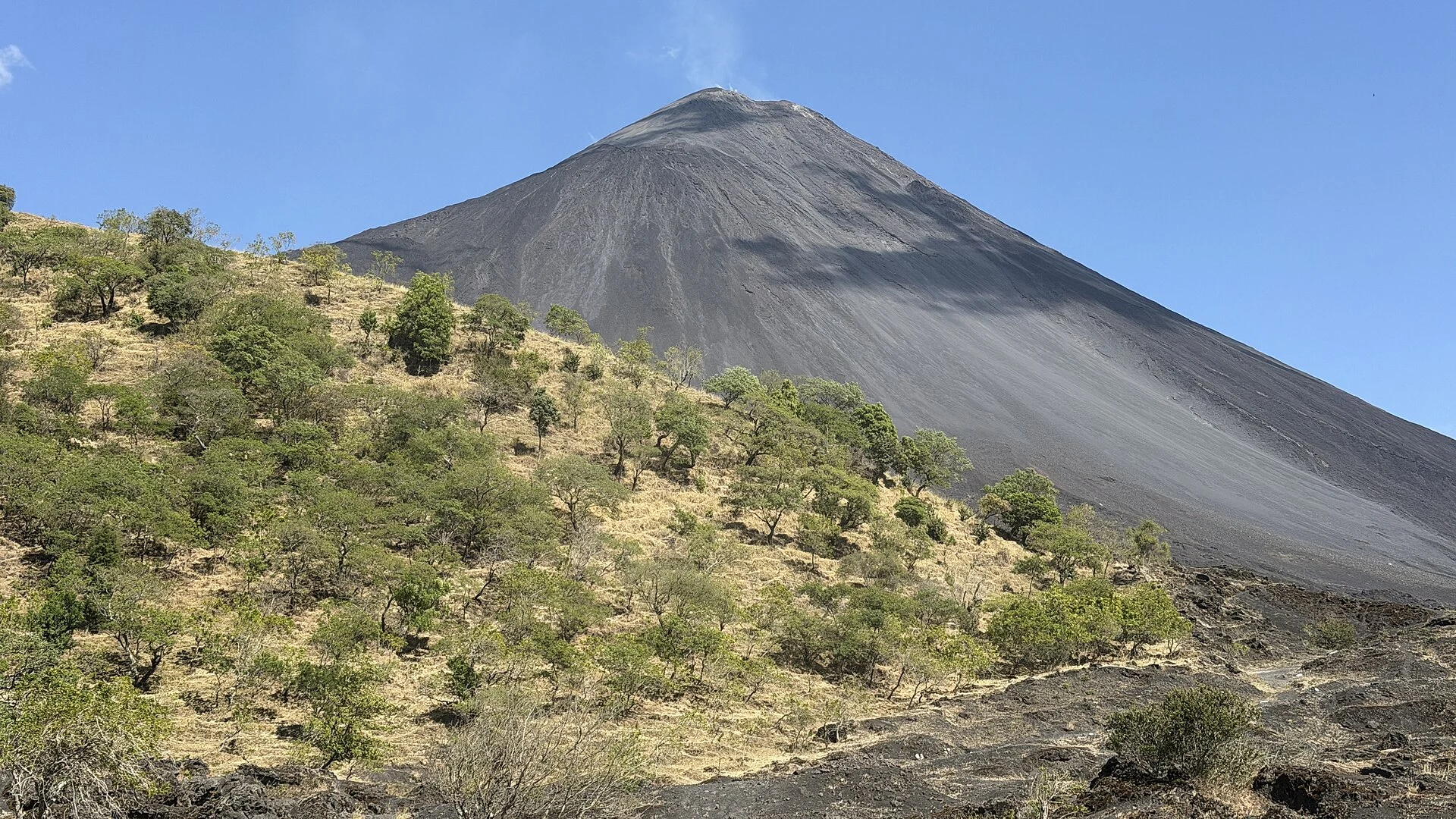
We do not choose a type label by looking at a travel photo. A visible cone may be only part of the record. The source's science account is stronger evidence than an image's outline. Read the type label first. Then use the picture to understand the view.
| Source wording | Level of description | How to use it |
|---|---|---|
| Composite landform | GVP's main Pacaya record | Preserve the field name when citing it |
| Complex volcano type | GVP's main Pacaya record | Describes the wider volcanic place |
| Mackenney stratovolcano | Named feature within Pacaya | Keep the cone name with the label |
| Modern basaltic stratovolcano | Oregon State's account | A more specific description within its wider complex account |
Scroll for more →
The final row comes from Oregon State University's Volcano World description, also checked October 2026. Its account includes older features as well as the modern cone. It supports reading Pacaya as more than one simple shape. It does not give a live visitor-access assessment.
Why a complex can contain a stratovolcano
Think about the difference between a place and one feature inside it. A wide volcanic landscape can include several edifices and other forms. A cone within it can have a more specific description. Calling the larger place a complex does not remove the cone's identity.
The word complex is useful here because the wider geology is not captured by one ideal cone. The Smithsonian account includes older edifices and a younger cone within a changed landscape. Keep those links in mind when reading a short label. The source is describing a whole with parts.
An one cone can be the focus of a photo or a recent report. That does not mean the wider complex has become only that cone. Likewise, a list of several feature names does not make each a separate national record. The level of description remains important.
A useful sentence therefore names both levels. You can describe Pacaya as a volcanic complex and name Mackenney as a stratovolcano within it. This avoids forcing one term to do every job. It also tells the reader which part a later sentence refers to.
Composite volcano and stratovolcano in plain language
The USGS overview of principal volcano types explains composite volcanoes, also called stratovolcanoes, as edifices built from lava and erupted fragmental material. The key idea is a volcano built through repeated additions. It is not simply a heap of one uniform substance. Shape and internal history both matter to the description.
The familiar cone is a simplified picture. A real edifice can be cut by erosion, changed by collapse or partly covered by later deposits. Its outline need not match a classroom sketch. That is why a photo alone is a weak way to assign a precise type.
The terms do not give the order of each layer. They also do not imply that all layers have equal thickness. A simple educational diagram leaves out many real details. Read it as a model of the idea, rather than a surveyed cross-section of Pacaya.
When writing about a source, preserve its wording. If it says stratovolcano, use that term and explain it. Do not replace it with a more familiar label that changes the meaning. A short definition can make the science accessible without discarding it.
A cone, a crater and a vent are distinct things
A cone is a built-up volcanic landform. A crater is a depression associated with a volcanic feature. A vent is an opening through which material can emerge. These words answer distinct questions about the shape and its processes.
The USGS geological glossary provides definitions for volcanic terms, including vents and stratovolcanoes. Use a glossary to understand the noun before applying it to a photo. A dark hollow seen from a distance may not reveal the whole feature. The place-specific source should name what it is.
In ordinary travel writing about the crater and volcano are sometimes used loosely. A sentence about a crater can appear to describe the entire mountain. Be more precise when planning a visit. Ask whether a route is near a named feature rather than assuming the words mean the same place.
The distinction also matters for access. Identifying a crater scientifically does not mean visitors may approach its rim. A route can pass through a volcanic landscape without reaching that feature. Keep geological naming separate from the guide's allowed endpoint.
Domes and flows in the wider account
A lava dome and a lava flow describe distinct forms of erupted material. They can be part of a complex without defining the whole place by themselves. Oregon State's Pacaya description includes domes and flows among its components. The broader label helps accommodate that variety.
Do not assume that seeing a flow makes the whole volcano a shield volcano. A flow is a product of activity, while a volcano-type label describes a larger form or system. One product is not the whole type label. The named source should connect the evidence to the label.
Likewise, a rounded feature is not enough to name a dome from a casual photo. View angle and distance can conceal its shape. Read the caption and source description. If neither names the feature, keep the visual description modest rather than inventing a name.
The practical lesson is to keep part and whole distinct. A complex may include forms with their own names and histories. A visitor can learn from one of them without seeing every part. The type label does not require a tour to cover the whole landscape.
Rock type is another question
Basaltic describes a composition, rather than simply meaning cone-shaped or active. The Smithsonian record has a rock-type section separate from its form fields. Oregon State also uses basaltic in its account of the modern cone. Read that word as part of a source description, not as a visitor-access rating.
A rock label and a landform label can appear in the same sentence. They are not competing answers to one question. One concerns the material; the other concerns the edifice or system. Keeping the categories apart makes the sentence clearer.
Do not name a rock's full composition from colour alone. Lighting and surface changes can affect how it looks in a photo. A named sample with a science description is a distinct kind of evidence. A landscape image does not replace that record.
Nor does the word basaltic predict one fixed eruption style in every future event. A type description is not a forecast. Use monitoring sources for a current assessment. The past geology explains context without promising what will happen next.
Type is not the same as eruption style
A volcano-type label describes a form or system. An eruption-style term describes the character of activity. A source can use both. They do not have to conflict. Do not treat a word about one eruption as a replacement for the wider type label.
The Smithsonian's Pacaya archive describes several kinds of observed activity over time. Its past reports include explosive processes as well as lava flows. That record is richer than a single marketing image. A short label should not erase those differences.
If you encounter a technical activity term, keep its source and date. A description of a past episode is not a promise that the same style is occurring now. The terms belong to the event or period described. A current assessment needs a current actual bulletin.
This page does not infer today's activity from the shape of the cone. Shape can remain visible between distinct periods of activity. A plume in a photo also needs a date and explanation. Type, appearance and monitoring are related subjects with separate evidence needs.
Active, dormant and extinct do not replace the form label
These words concern activity or its interpretation, rather than the same question as complex or stratovolcano. They need definitions and time frames. A source can call a volcano active while also describing its landform. Those are distinct parts of the account.
Do not assume that a catalogue's past last-eruption date means a volcano is extinct. It records what the database reports under that field. It does not make every current observation unnecessary. Nor does a lack of a new retrieved bulletin prove quiet conditions.
The reverse mistake is to treat an active label as proof of visible lava on demand. Activity can be described through distinct observations. A tour cannot promise a fixed display simply by using the word active. Ask what the allowed walk can show on your actual date.
For the present page, keep the answer focused on form. Use the named primary source's type label and explain its scale. Current monitoring and access require separate checks. The type label cannot resolve them.
Formation history helps explain the variety
Pacaya's wider science account includes older edifices and collapse, plus later cone growth. That sequence helps explain why the place is called a complex. A modern view is the result of changes over time. It is not a single untouched cone built in one event.
Classification and formation are still distinct tasks. The type label tells you how the source groups or describes the place. The formation account explains the processes and sequence behind it. A type label alone is not a full chronology.
Do not attach one age to every feature because they share the Pacaya name. A younger cone and older surrounding forms can have distinct histories. Dates should stay with the feature or event they describe. A photo capture date is another category again.
This is also why a simplified diagram should be labelled as such. It can show the relation between whole and parts. It should not pretend to map underground structures or date every layer without evidence. A clear text explanation is better than an unsupported detailed cross-section.
Reading the source at the right scale
Start with the title of the record. Then read the field labels and summary before selecting a phrase. A source may describe the main volcano in one place and a smaller cone in another. Quoting a label without its subject can make a correct source appear inconsistent.
Look for a feature list or synonyms. The same place can have several spellings or names across sources. Check whether a term is a name, a type or a translated label. Do not count a spelling change as a new volcanic feature.
Keep the source's date or the date you checked it. A current website can host an older educational account. The page may still be useful, but its present accessibility does not make every observation current. Preserve the difference between reference details and live reporting.
When comparing two sources, ask whether they cover the same object. One account can describe the whole complex. Another can describe a cone.
Both can be valid. A true disagreement needs statements at the same scale. Do not manufacture a conflict simply because the words differ.
A worked reading of two short descriptions
Suppose one sentence says Pacaya is a complex. Another calls Mackenney a stratovolcano. The first names the wider place. The second names a feature within it. There is no need to choose a winner between those sentences.
Now suppose a travel page says only that Pacaya is a stratovolcano. That may be a shortened description centred on the modern cone. It is less complete about the wider landscape. Check the source before repeating it as the only possible answer.
The improved version names the scale. State that Pacaya is a volcanic complex which includes the Mackenney stratovolcano. If using the GVP fields, preserve Composite as its landform label and Complex as its type label. Give the source with the explanation. They can fit in a short paragraph.
This approach is useful for a school note, a photo caption or a travel plan. It keeps the answer clear without forcing the reader through every detail about the place. The extra context is there for those who need it. A one-line answer can be brief. It can still be clear about its subject.
Why a photo is not a type label test
A single view can hide older forms behind the most prominent cone. It can also merge separate ridges into one outline. Cloud can conceal the lower landscape. The view can be accurate. It can still leave out much of the complex.
Distance changes what you can distinguish. A nearby surface texture may be visible in one frame while the broader shape is absent. A wide view may show form but no clear rock detail. Neither should be asked to answer every geological question.
The real photo on this page has its own date and source credit. It documents a scene rather than a current monitoring result. The caption does not claim to establish type from the visible outline. Classification comes from the cited source records.
Use named captions carefully. A label such as crater or dome, or a cone should have source support for that subject. If a feature is not named, describe what is visibly there without inventing a feature name. That leaves room for a later correction based on better evidence.
A small glossary for reading Pacaya descriptions
An edifice is the built volcanic body. In plain language, it is the landform made through volcanic construction. The term helps distinguish a physical structure from a record. A wider record can describe more than one such body.
Pyroclastic refers to fragments produced by explosive volcanic activity. It does not mean that every rock a visitor sees was formed in the same event. The term describes origin or material. A source must still connect a specific deposit to a place and age.
A flow is material moving or formerly moved along the surface, depending on the context. A hardened flow remains part of the landscape after movement ends. The word therefore needs a date when used to discuss activity. Old flow rock is not proof of a present moving front.
A caldera is a large volcanic depression with a distinct scale and origin from a simple summit crater. Do not use the terms as interchangeable labels for any hollow. The place-specific account matters. A map or photo alone may not explain how a depression formed.
These brief explanations help read the sources; they are not a new set of type labels. The USGS glossary linked above supplies word meanings. Pacaya's own record supplies the local names and links. Use both kinds of source for their proper task.
Avoiding the most common label mistakes
Do not replace complex with complicated as if the words had the same science role. In this context complex is a label in the source. An ordinary judgment that a place is hard to understand is another matter. Explain the category through its parts instead of making it sound vague.
Do not call every dark surface ash. Ash is a material term, not a synonym for all volcanic ground. The same view can contain rock from distinct processes. Keep the visual description separate from a material identification unless the source supports it.
Do not call a volcano a crater merely because a route looks towards a hollow. The crater is a feature of the volcanic landscape. It is not the whole system. Naming the part accurately helps avoid an access misunderstanding too.
Do not turn a type label into a promise about effort. A complex does not mean a complex walking route. A stratovolcano does not mean every visitor climbs its full height. The actual allowed path is the relevant unit for judging the visit.
The regional setting does not make the volcanoes identical
Pacaya is part of a wider volcanic region. That does not make nearby volcanoes the same form or trip. Each has its own record and history. Do not borrow one volcano's features to explain another. A distant view can include several distinct subjects.
The nearby-volcano guide separates a view from Antigua, a Pacaya day walk and other mountain-trip formats. That practical distinction complements the geological one. Walking on one volcano while seeing another does not merge them into one place. Ask which name describes the path and which describes the view.
A similar-looking cone can still have a distinct source history. Shape is useful context, but it is not a complete identity check. Use the named record rather than recognition alone. The same care applies when a photo has been shared without its original caption.
This page does not expand the regional comparison into a national destination list. Its purpose is to explain Pacaya's type. The regional context matters only as far as it clarifies the place. Keep the geological subject and the visitor decision in focus.
What the type label tells a visitor
It explains why the place is more than one peak. It also helps make sense of distinct names in source descriptions. A guide may discuss an older form while the most visible cone belongs to a later stage. The type label gives a framework for that explanation.
It does not tell you the entrance, walking distance or return time. Those belong to the actual trip. The hiking guide asks for a named allowed endpoint and a pace plan. A geological term cannot fill those practical gaps.
It also does not confirm current access to any named feature. A science feature list is an inventory, not a menu of places visitors may enter. A well-known cone can be outside the allowed route. Current instructions take precedence over a past visit account.
Use the type explanation to understand what you see from the route you are allowed to use. Ask the guide which features can be named from there. You can learn about a complex without approaching every part. A clear explanation can be valuable even when a specific view is hidden.
How to write a concise sourced answer
Start with the broad type label and name the source. Add the specific cone only if it helps the question. Explain that the labels refer to whole and part. Stop before adding a live activity claim that the source does not establish.
For a longer answer, split the ideas into short paragraphs. One can cover form, another material and another history. Give each its own evidence. This is clearer than putting many terms in one sentence. Explain how the terms fit together.
If you are translating the answer, preserve the subject and scale. Spanish complejo volcánico and estratovolcán refer to distinct levels in the same way here. A translation should not change the whole complex into one crater. Keep the source name and the named feature intact.
For a caption, name what the image actually shows. If it shows a general Pacaya landscape, say so. Do not label every visible ridge Mackenney without evidence. The type label can be explained in the article without overclaiming the photo's detail.
Read the named features without merging them
The Smithsonian feature list gives more detail than the main type field. It names Cerro Chino as a pyroclastic cone and Cerro Chiquito as a dome. Cerro Grande and Mackenney appear as stratovolcanoes. These names help explain what the wider complex description contains.
| Named feature in the GVP record | Feature type shown by the source |
|---|---|
| Cerro Chino | Pyroclastic cone |
| Cerro Chiquito | Dome |
| Cerro Grande | Stratovolcano |
| Mackenney | Stratovolcano |
Scroll for more →
Source: the Pacaya GVP profile linked at the start, checked October 2026. The table preserves named feature categories from that record. It does not declare each feature a separate visitor destination. It also does not assign present activity to every row.
Start by reading across a row. The left side tells you which feature is being discussed. The right side tells you how the source describes it. Do not carry the type from one row into another merely because the names are nearby in a list.
Then step back to the whole record. The presence of distinct feature types makes the broader account easier to understand. A complex label can sit above those rows without replacing them. The table is a set of parts within the place, rather than a choice of rival names for one peak.
A dome and a pyroclastic cone are not simply smaller spellings of stratovolcano. They describe other forms in the source's account. Keep that distinction when taking notes. A short list can preserve it better than a sentence that calls everything a cone.
At the same time, do not infer more than the table says. A named type does not date the feature. It does not explain every deposit on its slopes. It does not tell you where a person may stand today. Those questions need further evidence.
The spelling of a name can vary between publications. Match the feature through the source context before treating the difference as a disagreement. A translation may also retain the local place name while translating the type. The link between name and category is what matters.
If a guide points out a feature from an allowed viewpoint, ask which name they are using. You can then connect the explanation with the record later. Do not assume the nearest visible peak is the feature mentioned. A landscape view can compress several shapes into a narrow field of view.
This also helps with captions. A caption may safely name the general complex when the smaller feature is not established. It should not gain a more specific label just to sound technical. Precision means making the claim that the evidence supports.
For a classroom summary, the feature table can accompany the broad answer. Explain that one main volcano record contains distinct named landforms. Then give one or two examples with their source labels. The result is more informative than memorising a single word without knowing its scale.
Limits of this type guide
We have not made a new geological map or surveyed the volcanic system. The page explains published primary and academic descriptions. It does not resolve every age or boundary in the research literature. Unstated details should remain unstated rather than being filled with a plausible diagram.
Nor does it forecast an eruption. Current monitoring requires a recent actual report and an interpretation by the responsible specialists. The form of a mountain alone cannot provide that. A past observation should stay attached to its date.
This page also makes no claim that a source label settles visitor safety. A permitted trip plan, current instructions and the needs of your party remain separate considerations. Choose a visit through those details. Keep geology as context rather than a substitute for them.
Continue with these guides
Verdict: state Pacaya volcano type with its scale
The clearest Pacaya volcano type answer is a volcanic complex with named cones, including the Mackenney stratovolcano. The checked GVP record uses Composite for landform and Complex for type. Preserve those field names when citing them. Do not force a whole landscape and one cone into a false either-or choice.
The Pacaya overview connects this type label with the wider place. Use it to move from a technical label to the questions that matter for a visit. A source-based answer can be precise without pretending to be a live access report.