
A Guatemala volcano map with Pacaya in context
Map 20 Smithsonian volcano records with elevations and recorded eruption years. See roads between Antigua, Guatemala City and Pacaya, with sources and zoom.
Last reviewed October 2026

Contents7
This Guatemala volcano map shows 20 Smithsonian Holocene records along the Pacific belt. Pacaya is the yellow point. The numbers match the table. The closer road map below places Pacaya beside Antigua and Guatemala City.
Use the national view to identify volcanoes and the road view to understand the road approach. A town is not a volcano entrance. Check which place a label names.
In brief: Pacaya lies southeast of Antigua, beyond Agua in the road view. Fuego and Acatenango form a close pair west of Antigua. The drive to Pacaya uses CA-9 and local roads near San Vicente Pacaya. Ask your guide which entrance to use before you travel.
Guatemala volcano map: the national volcanic belt
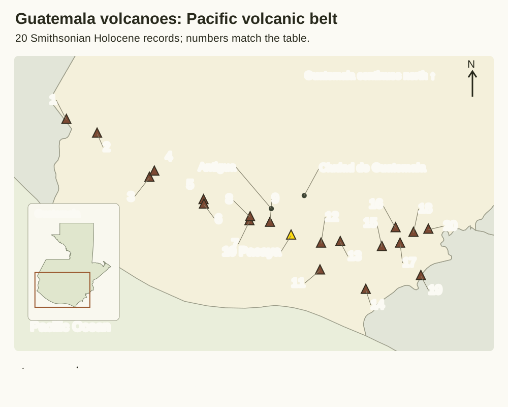
The triangles follow the Holocene list from the Smithsonian Global Volcanism Program. Each has a number. This is one science list.
It includes Tacaná and Chingo on shared borders. It is not a list of every mountain that people climb in Guatemala. Other lists use different totals.
The guide to Guatemala's volcano count explains the scope of each.
The main map shows the southern belt. This keeps the points spread out and useful. The small inset puts that belt inside the whole country.
Northern Guatemala continues beyond the main map. Yellow marks Pacaya, the subject of this guide. The colours do not show current activity.
They also do not show where you may enter.
Volcano names and elevation, with recorded eruption year
| No. | Volcano and record | Elevation (m) | Last eruption: catalogue year |
|---|---|---|---|
| 1 | Tacaná | 4,064 | 1986 |
| 2 | Tajumulco | 4,203 | Not dated |
| 3 | Santa María | 3,745 | 2026 |
| 4 | Almolonga | 3,173 | 1818 |
| 5 | Tolimán | 3,158 | Not dated |
| 6 | Atitlán | 3,535 | 1853 |
| 7 | Fuego | 3,799 | 2026 |
| 8 | Acatenango | 3,976 | 1972 |
| 9 | Agua | 3,760 | Not dated |
| 10 | Pacaya | 2,569 | 2021 |
| 11 | Tecuamburro | 1,845 | 960 BCE |
| 12 | Cuilapa-Barbarena | 1,454 | Not dated |
| 13 | Jumaytepeque | 1,802 | Not dated |
| 14 | Moyuta | 1,662 | Not dated |
| 15 | Flores | 1,600 | Not dated |
| 16 | Tahual | 1,716 | Not dated |
| 17 | Cerro Santiago | 1,192 | Not dated |
| 18 | Suchitán | 2,042 | Not dated |
| 19 | Chingo | 1,775 | Not dated |
| 20 | Ixtepeque | 1,292 | Not dated |
Scroll for more →
Source: Smithsonian GVP Holocene volcano data service, checked October 2026. The numbers match the map from west to east. Elevations are metres above sea level in that dataset. Each name links to its individual science record.
“Not dated” means the retrieved record has no last-eruption year. It does not mean the volcano will never erupt again. It does not promise a safe visit.
A year of 2026 is a value from the list. It is not a live report. It does not prove activity today.
Do not use the year alone to decide if you can visit.
The list can group a field or complex in one record. One triangle cannot show the full shape of each cone. It also does not mark a national-park boundary. Keep those distinctions when comparing a map label with the name of a commercial excursion.
Pacaya, Antigua and Guatemala City by road
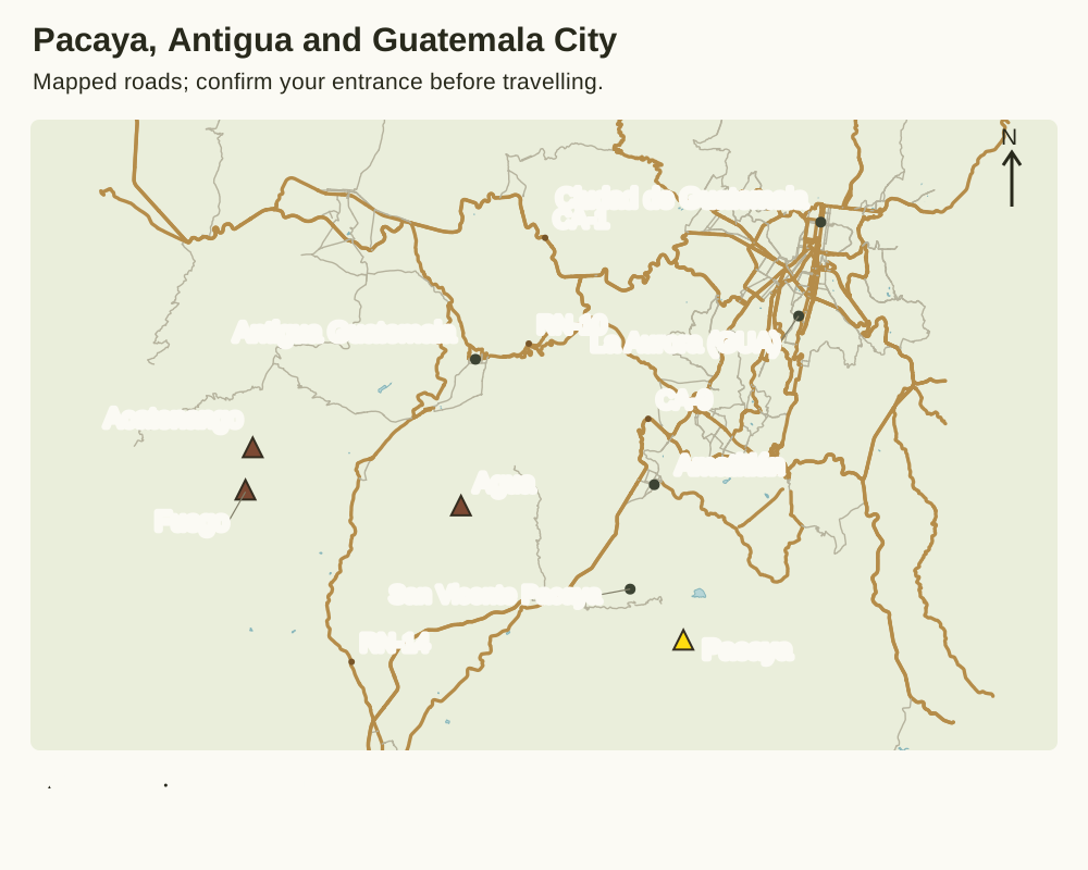
The road view adds roads and towns from OpenStreetMap. A volcano can look close in a photo from Antigua. That does not mean there is a direct road to it. Agua stands between several familiar views and the wider Pacaya area. The road network follows the developed valleys and towns rather than straight lines between summits.
CA-1, RN-10 and RN-14 help orient the Antigua side of the region. CA-9 is the main capital-to-Pacific corridor shown east of Agua. The Ministry of Culture's Pacaya entry describes access from the capital using CA-9, then San Vicente Pacaya and the villages of El Cedro and San Francisco de Sales. That description identifies an approach, not the state of every road or today's meeting desk.
La Aurora is the airport context for a Guatemala City arrival. A booking must still name where to meet after landing. The volcano triangle is not an airport pickup. A city label does not name your hotel. Send the address from the reservation along with any map link.
Read the map at the right scale
On a phone, swipe inside the map area to keep the labels large. Tap the image to open the full version and zoom. The table gives the names in text too. Keep its number with the name when moving between the national view and the table.
North is at the top of each map. Road lines reproduce mapped geometry, while labels are moved slightly to keep them apart. A thin leader connects an offset label to its point. A road line is not a walking trail, and a volcano symbol is not a car park. Follow the legend before treating two nearby symbols as one destination.
Do not use the image to work out a drive time. The maps are static guides to the place. They have no traffic feed.
They do not show roadworks or live closures. A driver needs the booked entrance and a current road plan. The drive can be much longer than the gap between points.
Sources and reuse
Roads and settlements are drawn from the OpenStreetMap Guatemala extract distributed by Geofabrik, retrieved 15 October 2026. Map data © OpenStreetMap contributors, available under the Open Database Licence. See OpenStreetMap's attribution page for the underlying data terms. This is a new static drawing from the data, rather than a screenshot of commercial map tiles.
The country outline comes from Natural Earth, whose map data is public domain. Volcano points and catalogue values come from the Smithsonian service cited above. No proprietary visitor track has been copied. The closer map shows selected roads. It does not show every lane or path.
Download the OSM data used for these maps under ODbL 1.0.
From a map name to a visit plan
First choose the place you want to visit. Then confirm the entrance and date, plus the allowed walking route with the people responsible for your outing. Ask whether your driver and guide expect you at the same point. If they name different places, resolve that before the vehicle leaves.
The Pacaya overview explains the complex behind its map symbol. The hiking guide covers route and pace questions once the arrival plan is clear. A past eruption record does not grant entry to the active cone. Nor does an open road. Current park instructions take precedence over a saved map.
Keep the map with its legend
When sharing a screenshot, include the title and source line. A cropped point can lose both its name and its purpose. For a transport booking, also send the exact meeting address.
Ask what the seller's pin marks. Check why it differs from the village name. A science point shows the place. A pickup plan explains where to meet.
Verdict: use each map for its own task
Use the national Guatemala volcano map to connect names with the volcanic belt. Use the roads shown to understand the relation between Pacaya and your starting base. Confirm the final entrance separately. Use each view in turn. Keep the science point apart from a route you have not yet checked.