
Pacaya location and visitor access points
Locate Pacaya using scientific coordinates and official park context. Keep the volcano point separate from an entrance and a road destination.
Last reviewed October 2026
Contents8
- Pacaya location in the science record
- Pacaya approach villages and roads
- The park and administrative place names
- Your starting base is not the volcano entrance
- Obtain an address you can actually use
- Coordinates are not permission
- A location check before leaving
- Verdict: use Pacaya location at the right scale
The Pacaya location in southern Guatemala is in the Guatemala–Escuintla area. It is a volcanic complex. Its science coordinates name the volcano, not a place to drive a vehicle. For a visit, obtain the named entrance and guide meeting point apart. Do not send a driver to the catalogue point as if it were a street address.
In brief: distinguish the volcano, the protected area and your actual arrival point. A road transfer ends at a service location, while a science map marks a volcanic feature. The right place name is only the start of planning the visit.
Pacaya location in the science record
The Smithsonian Global Volcanism Program places Pacaya at 14.382° N, 90.601° W. We checked the record in October 2026. This is a reference position for the volcanic complex. It is not presented here as a visitor entrance or walking endpoint.
The complex includes several named features. A single map point cannot show the outline of all of them. Nor does it mark the boundary of a national park. Read the feature name and source before deciding what a location pin means.
| Location term | What it names |
|---|---|
| Pacaya science point | The volcano record in the cited catalogue |
| Pacaya and Laguna de Calderas park | The protected-area identity in the official listing |
| Visitor entrance | The arrival point that needs current answer |
| Walking endpoint | The place the group is allowed to reach on its date |
Scroll for more →
These categories can be close together without being the same place. A correct point for the volcano does not answer which gate a tour uses. A park name does not define the route through it. Keep the four labels separate in your travel notes.
Pacaya approach villages and roads
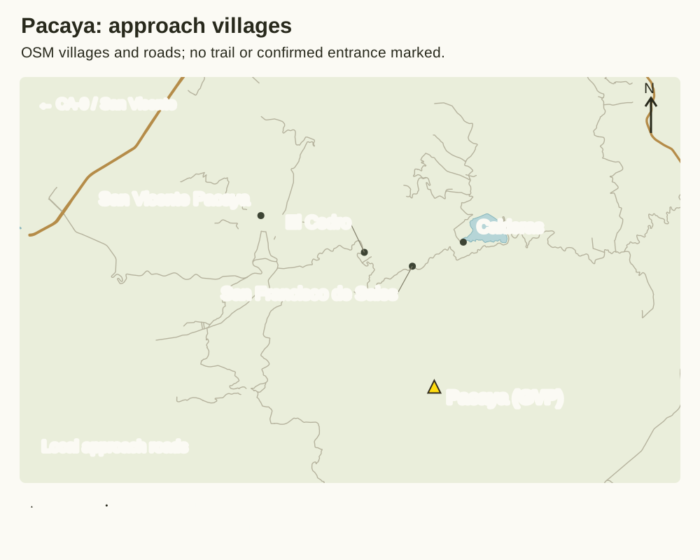
The map separates San Vicente Pacaya from the villages of El Cedro, San Francisco de Sales and Calderas. These are towns and villages. They do not mark an entry desk. The yellow triangle marks Pacaya in the Smithsonian science catalogue. It does not mark your walk’s start or end.
The Ministry of Culture describes an approach from the capital using CA-9, then San Vicente Pacaya, El Cedro and San Francisco de Sales. That list uses town and village names. A trip plan may name both. Ask the seller to name the actual entrance and guide meeting point.
Roads come from the Geofabrik OpenStreetMap extract, retrieved 15 October 2026. The roads keep their mapped shapes. Some labels move so they do not overlap.
North is at the top. Swipe inside the frame or open the full image to read the details. No walking track or park boundary is shown.
The final approach depends on your trip. A road on the map may not be the one your trip uses. It may also be closed today. Keep the written arrival address alongside the map link. If the driver proposes a different point, settle the guide meeting before changing it.
The park and administrative place names
The official CONAP visitor listing lists the park under Amatitlán and San Vicente Pacaya, in the departments of Guatemala and Escuintla. These names help name the area. They do not supply a current trailhead coordinate. We checked the listing in October 2026.
A department, municipality and visitor site are distinct levels of place. “Guatemala” can name the country, a department or the capital in travel conversation. Ask which one a seller means. A broad product title may not be precise enough to arrange pickup.
The national park guide explains the protected-area name and Calderas context. Do not assume that every place in the park name is included in a walking tour. A package needs to name its actual stops. The protected area and a commercial trip plan are not identical outlines.
Your starting base is not the volcano entrance
Guatemala City and Antigua are travel bases for distinct departure plans. La Aurora is the airport used in the usual city-arrival plan; the airline Avianca names it with GUA. That names an arrival airport, not a direct hiking start. The road journey still needs its own booking and destination.
An Antigua departure needs an Antigua meeting point. A city-based pickup should name the hotel or address served. Do not book one base and assume it includes a transfer from the other. Ask whether a road connection is part of the quoted service.
The approach map shows roads and villages, but not the meeting point for an individual booking. Obtain that point from the seller for your date. Also confirm where the vehicle waits after the walk. The return should be part of the arrival agreement.
Obtain an address you can actually use
Ask for the entrance name and meeting instructions in writing. If a map link is supplied, ask what the pin marks. It could be a car park, visitor centre or broad volcano label. The label should match the service you booked.
Keep a contact for the person meeting you. A driver may know the road without providing the walking guide. A guide may expect the group at a desk instead of beside the vehicle. Explain the handover so no one assumes the other party has arranged it.
Confirm where the walk ends and where the vehicle waits. Those points may need to change if the guide uses another allowed route. A current change should come with a clear return plan. Do not navigate to an older endpoint simply because it is saved on your phone.
Coordinates are not permission
A feature can be well mapped and still be outside the allowed visitor route. The science record describes where it is. It does not authorise approaching it. Current instructions remain separate from any coordinates in an article.
The same applies to photos. A view of a crater does not show whether the photographer was on a public trail, working under another plan or there in an earlier period. A caption helps with place and date, but it is not an access notice. Do not reproduce the location as a travel instruction without confirmation.
Use the hiking guide to ask about the actual route and pace. Its allowed endpoint matters more for the day than the summit pin. Keep road distance and walking distance apart as well. Neither can be calculated from a place name alone.
A location check before leaving
- Confirm your actual starting address and starting base.
- Obtain the named visitor entrance for the booked date.
- Check what any map pin represents before sharing it.
- Name the guide meeting and the driver handover.
- Confirm the walking finish and vehicle return point.
- Keep current instructions with the booking details.
The Pacaya overview gives the broader setting behind those practical details. Read it if you need to understand the complex before choosing an outing. A good plan connects that place with real service points. It does not ask a science coordinate to do every job.
Continue with these guides
Verdict: use Pacaya location at the right scale
Use the Pacaya location in the catalogue to locate the place. Use the protected-area source for its identity. Obtain a current entrance and allowed walk from the people responsible for your visit. Those are related answers, but they should never be collapsed into one pin.